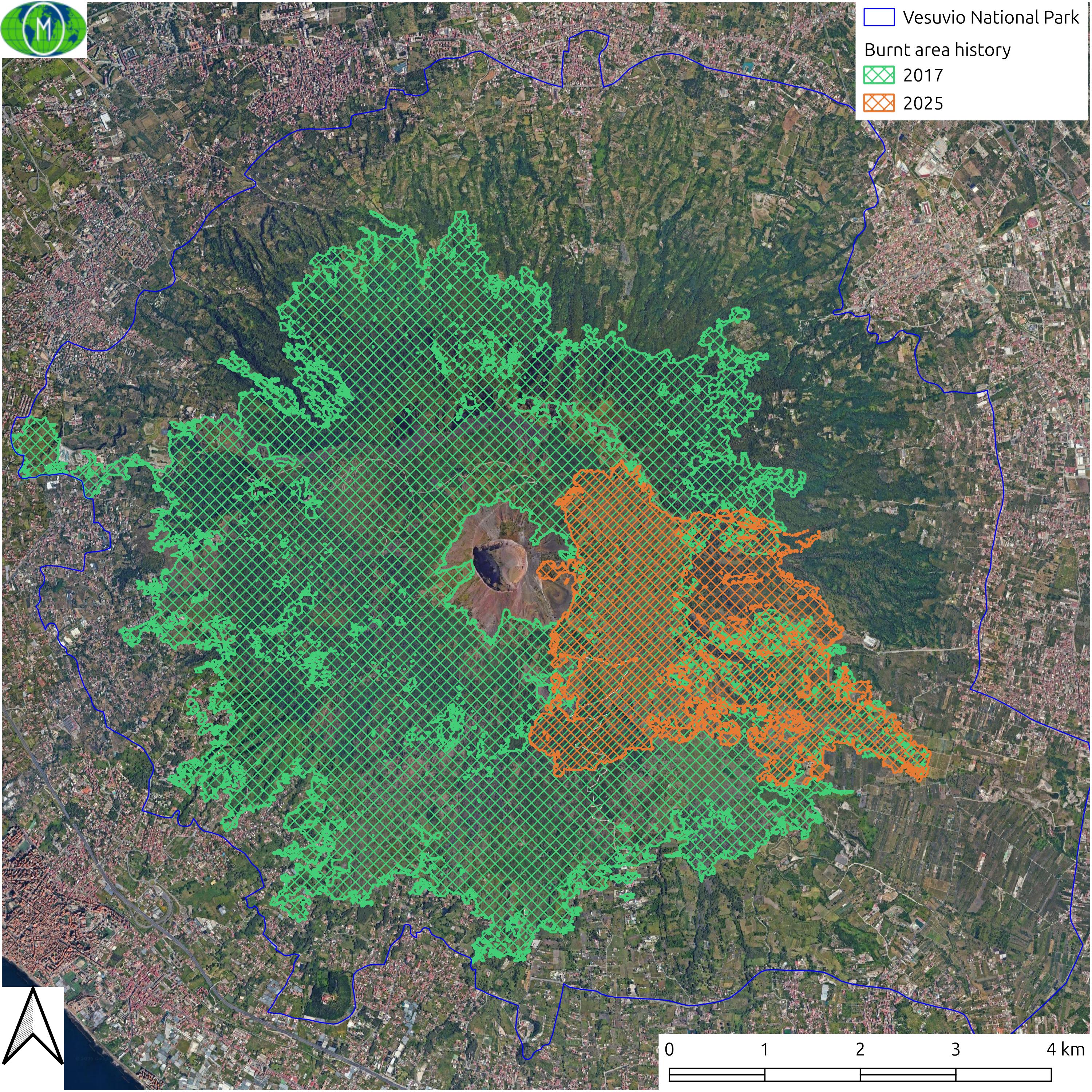
Ad inizio agosto 2025 il Parco Nazionale del Vesuvio è stato colpito da un nuovo vasto incendio dopo gli eventi dell'estate del 2017.
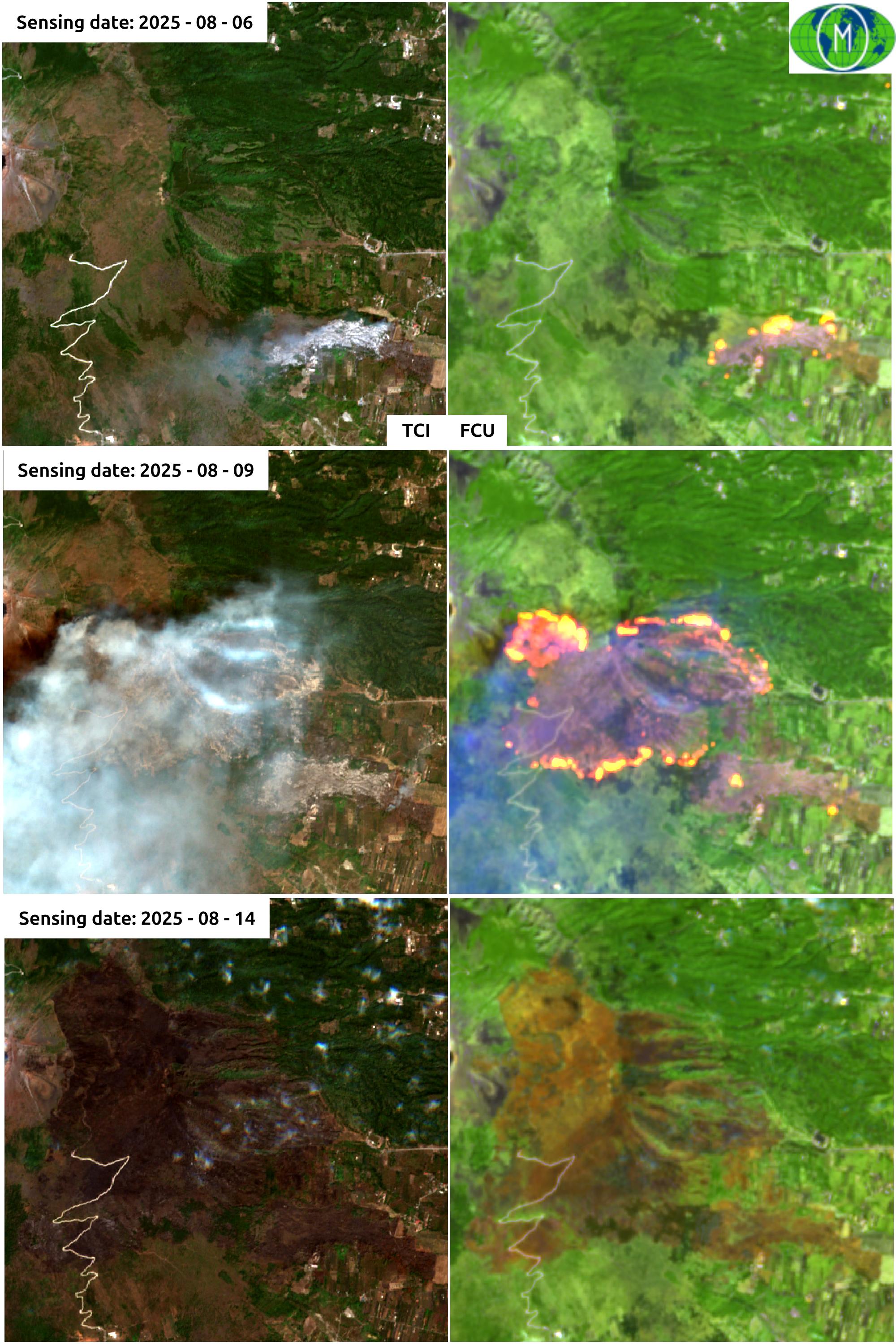
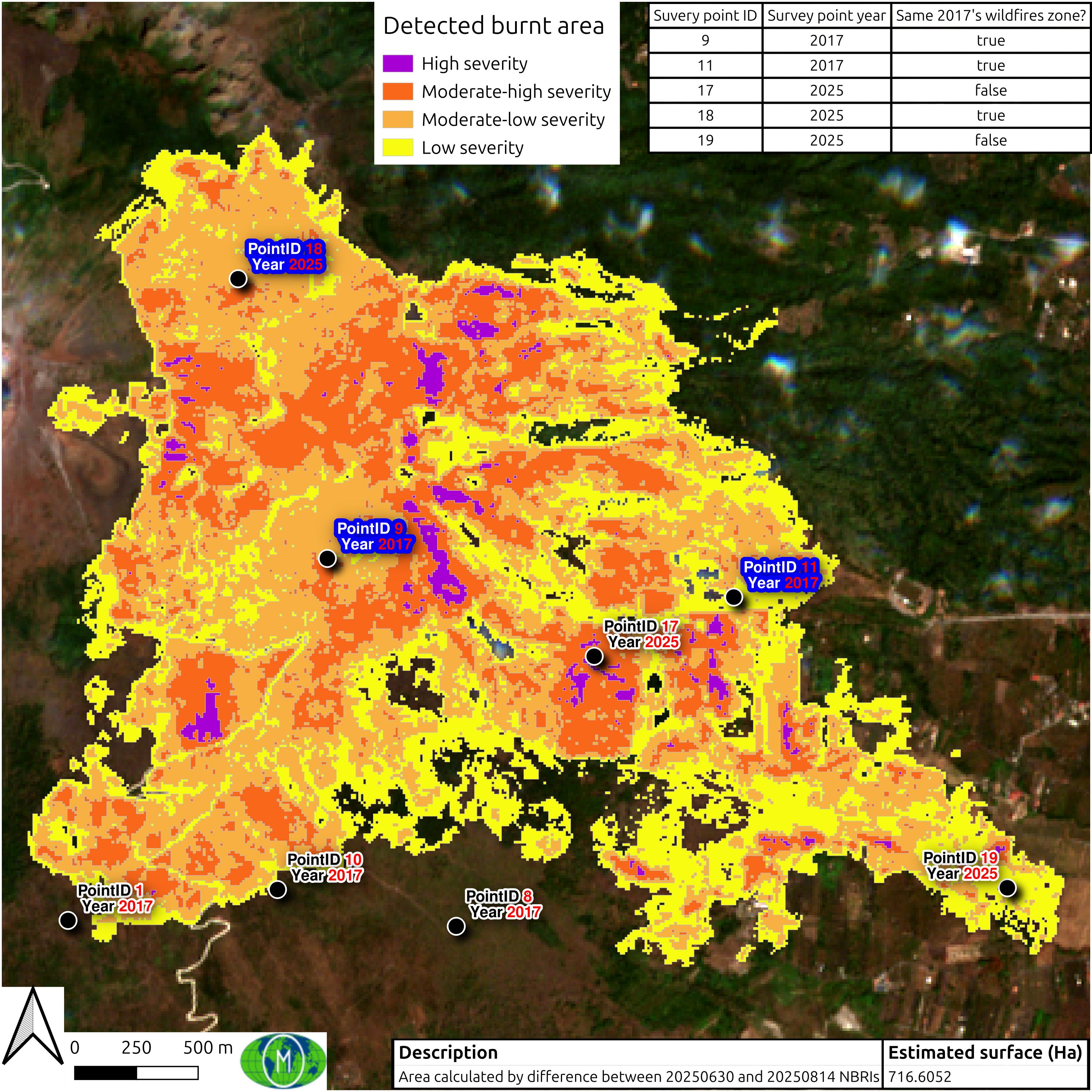
Grazie all'uso dei dati della costellazione Copernicus Sentinel 2 ho provato da stimare l'estensione dell'area percorsa dal fuoco estrapolando le classi di intensità di danno e quali aree dalla CLC2012 sono state colpite. Ho preferito usare la CLC2012 e non la CLC2018 perchè in quest'ultima è già presente la stima della perimetrazione delle aree percorse dal fuoco del 2017 e di cui non sono in grado di determinare l'entità del danno; per esperienza diretta non tutta l'area perimetrata è andata totalmente distrutta. Ho usato per questa analisi due scene Sentinel 2:
- S2B_MSIL2A_20250630T095029_N0511_R079_T33TVF_20250630T120527
| Comune | Estensione nel PNV (mq) | Estensione nel PNV (%) |
| Boscotrecase | 4.096.796 | 4,96% |
| Ottaviano | 9.379.583 | 11,35% |
| San Giuseppe Vesuviano | 2.871.204 | 3,47% |
| Terzigno | 16.642.077 | 20,13% |
| Torre del Greco | 13.627.623 | 16,48% |
| Trecase | 2.597.606 | 3,14% |
| Comune | CLC2012 | High severity | Moderate-high severity | Moderate-low severity | Low severity | Not burnt |
| Boscotrecase | Complex cultivation patterns | 1.140.182 | ||||
| Coniferous forest | 300 | 59.881 | 90.543 | 33.790 | 549.240 | |
| Land principally occupied by agriculture, with significant areas of natural vegetation | 1.029.296 | |||||
| Mixed forest | 9.734 | 42.577 | 16.465 | 152.402 | ||
| Transitional woodland-shrub | 13.186 | 48.530 | 65.547 | 518.150 | ||
| Ottaviano | Broad-leaved forest | 312 | 278 | 2.087.816 | ||
| Complex cultivation patterns | 47.428 | |||||
| Fruit trees and berry plantations | 25.332 | |||||
| Land principally occupied by agriculture, with significant areas of natural vegetation | 2.638.788 | |||||
| Mixed forest | 925 | 10.599 | 3.023 | 138 | 1.075.143 | |
| Sparsely vegetated areas | 3.600 | 30.724 | 40.705 | 216.926 | ||
| Transitional woodland-shrub | 18.288 | 574.672 | 1.014.979 | 261.407 | 357.216 | |
| San Giuseppe Vesuviano | Broad-leaved forest | 5.600 | 39.799 | 30.611 | 96.035 | 1.099.939 |
| Land principally occupied by agriculture, with significant areas of natural vegetation | 1.223.380 | |||||
| Mixed forest | 341 | 8.567 | 19.552 | 11.296 | 9.727 | |
| Transitional woodland-shrub | 793 | 1.948 | 2.140 | 141.717 | ||
| Terzigno | Broad-leaved forest | 2.627 | 9.271 | 6.520 | 1.587 | 1.612 |
| Complex cultivation patterns | 1.600 | 19.896 | 53.610 | 107.992 | 2.766.179 | |
| Coniferous forest | 5.300 | 80.221 | 339.616 | 684.190 | 1.077.833 | |
| Fruit trees and berry plantations | 16.614 | 78.258 | 115.551 | 89.138 | 3.640.587 | |
| Land principally occupied by agriculture, with significant areas of natural vegetation | 290.099 | |||||
| Mixed forest | 37.628 | 398.466 | 460.445 | 399.086 | 1.322.901 | |
| Transitional woodland-shrub | 63.477 | 430.790 | 548.751 | 376.666 | 1.395.249 | |
| Torre del Greco | Broad-leaved forest | 2.261.934 | ||||
| Complex cultivation patterns | 1.892.790 | |||||
| Coniferous forest | 47 | 281 | 685 | 3.499.757 | ||
| Continuous urban fabric | 177.078 | |||||
| Land principally occupied by agriculture, with significant areas of natural vegetation | 767.119 | |||||
| Mixed forest | 1.757.640 | |||||
| Transitional woodland-shrub | 351 | 1.415 | 3.547 | 1.713.021 | ||
| Trecase | Complex cultivation patterns | 1.529.580 | ||||
| Coniferous forest | 3.193 | 21.453 | 24.082 | 498.828 | ||
| Land principally occupied by agriculture, with significant areas of natural vegetation | 56.405 | |||||
| Transitional woodland-shrub | 24.846 | 52.955 | 27.779 | 201.792 |
| Comune | CLC2012 | Pre 2025 (mq) | Pre 2025 (%) | Post 2025 (mq) | Post 2025 (%) | Differenza (mq) | Differenza (%) |
| Boscotrecase | Complex cultivation patterns | 1.140.182 | 27,83% | 1.140.182 | 27,83% | 0 | 0,00% |
| Coniferous forest | 733.754 | 17,91% | 549.240 | 13,41% | 184.514 | 25,15% | |
| Land principally occupied by agriculture, with significant areas of natural vegetation | 1.029.296 | 25,12% | 1.029.296 | 25,12% | 0 | 0,00% | |
| Mixed forest | 221.178 | 5,40% | 152.402 | 3,72% | 68.776 | 31,10% | |
| Transitional woodland-shrub | 645.413 | 15,75% | 518.150 | 12,65% | 127.263 | 19,72% | |
| Ottaviano | Broad-leaved forest | 2.088.406 | 22,27% | 2.087.816 | 22,26% | 590 | 0,03% |
| Complex cultivation patterns | 47.428 | 0,51% | 47.428 | 0,51% | 0 | 0,00% | |
| Fruit trees and berry plantations | 25.332 | 0,27% | 25.332 | 0,27% | 0 | 0,00% | |
| Land principally occupied by agriculture, with significant areas of natural vegetation | 2.638.788 | 28,13% | 2.638.788 | 28,13% | 0 | 0,00% | |
| Mixed forest | 1.089.828 | 11,62% | 1.075.143 | 11,46% | 14.685 | 1,35% | |
| Sparsely vegetated areas | 291.955 | 3,11% | 216.926 | 2,31% | 75.029 | 25,70% | |
| Transitional woodland-shrub | 2.226.562 | 23,74% | 357.216 | 3,81% | 1.869.346 | 83,96% | |
| San Giuseppe Vesuviano | Broad-leaved forest | 1.271.984 | 44,30% | 1.099.939 | 38,31% | 172.045 | 13,53% |
| Land principally occupied by agriculture, with significant areas of natural vegetation | 1.223.380 | 42,61% | 1.223.380 | 42,61% | 0 | 0,00% | |
| Mixed forest | 49.483 | 1,72% | 9.727 | 0,34% | 39.756 | 80,34% | |
| Transitional woodland-shrub | 146.598 | 5,11% | 141.717 | 4,94% | 4.881 | 3,33% | |
| Terzigno | Broad-leaved forest | 21.617 | 0,13% | 1.612 | 0,01% | 20.005 | 92,54% |
| Complex cultivation patterns | 2.949.277 | 17,72% | 2.766.179 | 16,62% | 183.098 | 6,21% | |
| Coniferous forest | 2.187.160 | 13,14% | 1.077.833 | 6,48% | 1.109.327 | 50,72% | |
| Fruit trees and berry plantations | 3.940.148 | 23,68% | 3.640.587 | 21,88% | 299.561 | 7,60% | |
| Land principally occupied by agriculture, with significant areas of natural vegetation | 290.099 | 1,74% | 290.099 | 1,74% | 0 | 0,00% | |
| Mixed forest | 2.618.526 | 15,73% | 1.322.901 | 7,95% | 1.295.625 | 49,48% | |
| Transitional woodland-shrub | 2.814.933 | 16,91% | 1.395.249 | 8,38% | 1.419.684 | 50,43% | |
| Torre del Greco | Broad-leaved forest | 2.261.934 | 16,60% | 2.261.934 | 16,60% | 0 | 0,00% |
| Complex cultivation patterns | 1.892.790 | 13,89% | 1.892.790 | 13,89% | 0 | 0,00% | |
| Coniferous forest | 3.500.770 | 25,69% | 3.499.757 | 25,68% | 1.013 | 0,03% | |
| Continuous urban fabric | 177.078 | 1,30% | 177.078 | 1,30% | 0 | 0,00% | |
| Land principally occupied by agriculture, with significant areas of natural vegetation | 767.119 | 5,63% | 767.119 | 5,63% | 0 | 0,00% | |
| Mixed forest | 1.757.640 | 12,90% | 1.757.640 | 12,90% | 0 | 0,00% | |
| Transitional woodland-shrub | 1.718.334 | 12,61% | 1.713.021 | 12,57% | 5.313 | 0,31% | |
| Trecase | Complex cultivation patterns | 1.529.580 | 58,88% | 1.529.580 | 58,88% | 0 | 0,00% |
| Coniferous forest | 547.556 | 21,08% | 498.828 | 19,20% | 48.728 | 8,90% | |
| Land principally occupied by agriculture, with significant areas of natural vegetation | 56.405 | 2,17% | 56.405 | 2,17% | 0 | 0,00% | |
| Transitional woodland-shrub | 307.372 | 11,83% | 201.792 | 7,77% | 105.580 | 34,35% |