
Last week I launched a small survey among my Linkedin contacts to see what they associate the word GIS with. For a while now I've been trying to make people understand what GIS really is, what approaching the GIS world means. In line with this commitment, this survey was born.
The question was clear, of course, as Ludovico Frate points out in the comments, the GIS includes all four answers that I entered but unfortunately at the moment the surveys on Linkedin do not allow multiple answers nor do they allow multiple answers. a number greater than four answers. Here are the results.
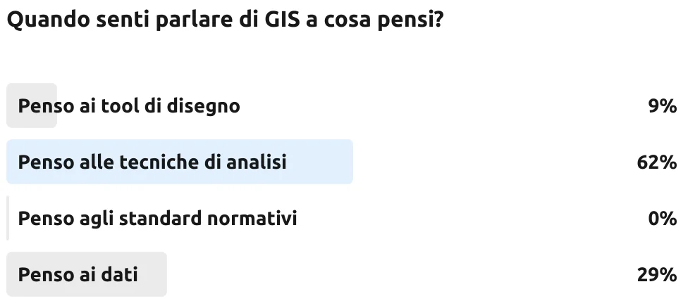
I'm pleased that analysis techniques come first, this answer goes in the direction of the correct approach to GIS and for those who answered that they think of a drawing tool it will take more time. a paradigm shift. Unfortunately, data is the great plague of the sector. If it is true that other data are obtained from the basic data, precisely thanks to the analysis techniques. It is also true that there is often precisely the lack of basic data. I understand and sympathize with those who think about data and who brought this answer to second place. Those who answered that they think about drawing tools would be better off using AutoCAD or Photoshop, they are more simple to use data modeling tool.
But no one has mentioned the regulatory standards. In my personal ranking I would have put the analysis techniques in first place, the regulatory standards in second place, the data in third place and the design tool in fourth place.
The basic data should derive from the regulatory standards, let's take the case of the road cadastre. The standard says how it must be modeled and therefore, based on the expected levels, there is It is possible to understand which one is the best analysis approach based on the required level. I wouldn't do a network analysis on level 0 but, based on needs, I would do it on level 1 or 2.
Which is your personal ranking? Write it in the comments.