Geoid, ellipsoid; normal; text-decoration: none; vertical-align: baseline; white-space: pre-wrap;">, proiezioni, DATUM termini sconosciuti troppo spesso a chi approaches the GIS world. Like any self-respecting discipline, GIS also has its rules, its fundamentals, essential actions that are the basis of any type of GIS-based project started by any professional. and knowing the meanings of the terms mentioned above is one of the fundamentals.
After this small but necessary premise I will try to respond as effectively as possible simple as possible to the question with which this article opens. What is the geoid for? What is the geoid?
TECHNICAL ANSWERthe Geoid is the equipotential surface of the Earth's gravitational field, coinciding with the free surface of the waters, if the seas and oceans could pass through the emerged lands. The geodesic surface is at any point perpendicular to the direction of the gravitational force. The trend of thegeodesic surfaceis affected by the distribution of masses and reacts to the presence/lack of mass ("mountains" attract the surface upwards, "ditches" produce depressions in the surface)
The geoid therefore, unlike theellisoideThrough gravimetria is It is possible to measure the gravitational field and know its intensity. at every point on the earth's surface. Since it varies from point to point on the earth's surface, defining a mathematical model that represents this distribution of forces, which defines the geodesic surface, is almost impossible also because it is not The distribution of the masses that make up our planet and which are one of the variables in the equation is completely known.
Why is what I just wrote important? Why if there is a difference in gravitational force between two points, there is a difference in the equipotential surface of the Earth's gravitational field and then between them there is a difference in height, a height that expresses the distance between those two points.
So we need the geoid to know the elevations of the earth's surface!
E’ strange? Pay attention, in some countries you can find signs or plaques that say "Height X above sea level". Sea level is measured with mareografi why not even he is constant; it varies with the tides and the tide gauges establish the average sea level, i.e. the average height of the sea in the place where they are located.
In the TECHNICAL ANSWER I wrote that the geodesic surface coincides with the free surface of the waters, if the seas and oceans could pass through the emerged lands. The free surface of the waters is the average marine altitude. Everything comes back.
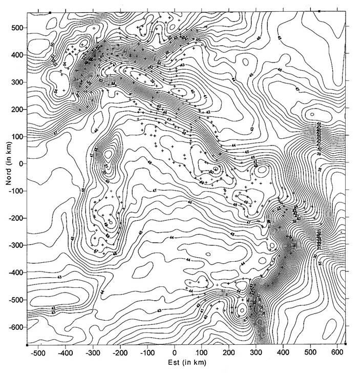
Below the representation of the geoid model ITALGEO valid for our territory where you can notice how the geodesic surface is not constant.