
Often in the support requests I receive, the problem encountered is due to a lack of knowledge of the concepts underlying reference systems. I noticed that one of the most recurring problems concerns map projections. In this article I will try to clarify what they are.
From the geometric-mathematical point of view, a projection is an “action”, a set of functions that are structured so as to “send” every point of one surface on another. Of course, what I wrote is an extreme simplification but, given that the public who interfaces with the GIS environment is not made up only of professionals who have taken the analysis 1 and 2 and linear algebra exams, we will make do!
More specifically, in the GIS world, a cartographic projection is a function intended to convert geographic coordinates (spherical) into Cartesian coordinates (metric), in other words, it brings onto a plane something that is actually three-dimensional so it can be represented more effectively. If a cartographic projection keeps the relationships between the surfaces constant, it is called equivalent (e.g. the sinusoidal projection), if it keeps the relationships between the distances constant, it is called equidistant (e.g. the equidistant cylindrical projection), while if it keeps the angles constant it is said to be conformal or equiangular (e.g. the conformal projection of Gauss).
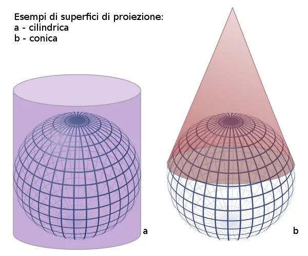 The type of function allows us to know the type of geometric surface onto which to project the earth's surface. This could in fact be a cylindrical surface, a conical surface or a flat surface.
Orientation helps us understand how the surfaces interact with each other. More specifically, if we consider a parallel, the projection surface can be normal, when the two entities are parallel; transverse, when the surface is orthogonal to the parallel; or oblique, when there is a certain inclination between the parallel and the surface.
The incidence type defines how the two surfaces come into contact. Let's assume that the projection surface is a plane, it can be tangent or secant to the Earth's surface.
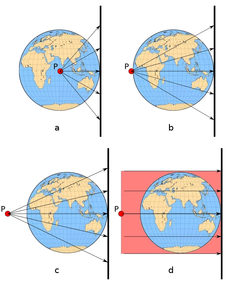 The center of emanation (P) defines the type of perspective projection. If it is coinciding with the center of the terrestrial globe we have a centrographic or gnomonic projection (a), if it is positioned on the opposite side to the intersection between the earth's surface and the projection surface we have a stereographic projection(b), if it is positioned on the opposite side to the intersection between the earth's surface and the projection surface and is external to the earth's surface we have a scenographic projection(c) while if it is positioned on the plane orthogonal to the intersection between the earth's surface and the projection plane we have an orthographic projection (d).
Choosing the type of projection will give us a representation of the Earth's surface that will have alterations in some places. Let's take the case of the Mercator projection, in the web map below you can see how distortions increase as we move away from the equator.
After what has been written, it should be clear that this topic should not be treated lightly and that the transition from one projective system to another, if done without criteria, can lead to big errors.
UPDATE 7 May 2018
In THIS page almost all existing map projections are collected, take a look!