
In July a arson fire of vast proportions affected the area of Vesuvius National Park generating extensive damage. With this article, in which I reworked the Copernicus data, I tried to quantify the extent of the types of soil destroyed also making use of the Corine Land Cover data and the DTM LiDAR of the Città Naples Metro.
During one of my bike training sessions in those days, I approached Monte Somma and the scenery was what you see in the following video.
The Park burned for almost a week on both the Monte Somma and Vesuvius sides.
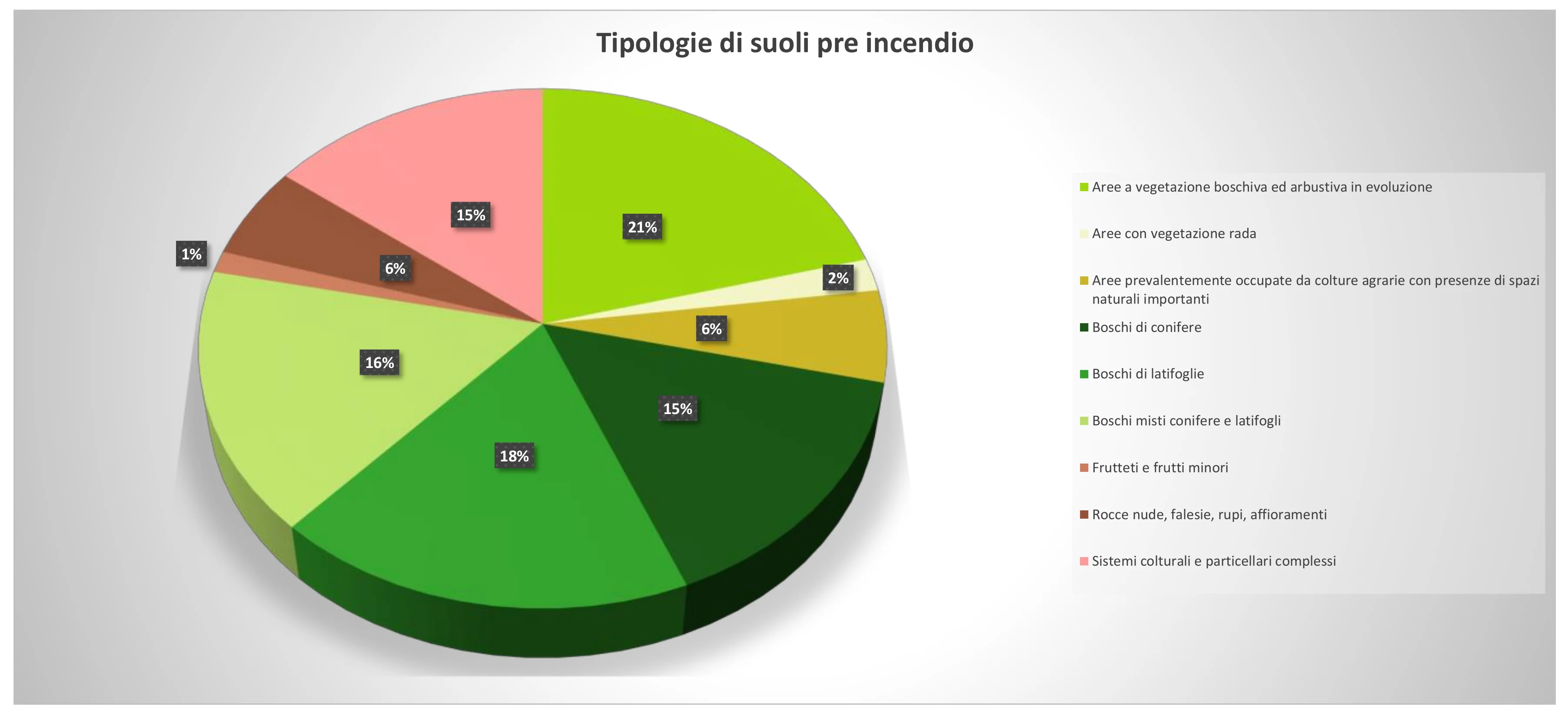
The following image shows land use before the fires, the data is an extrapolation of the CLC2000 present in the vector package downloadable from here.
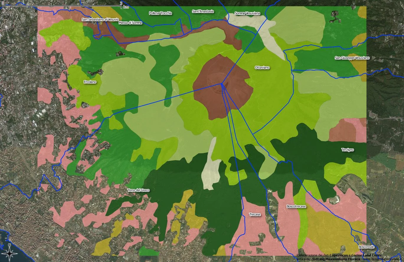
The total extent of the vectors that make up the different types of land use is equal to approximately 4,400 ha, appears to be more small compared to Copernicus data only because it is I preferred to focus on the areas of greatest damage.
| CLC2000 soil description | Type extension of soil (ha) |
Type extension of soil(%) |
|
|---|---|---|---|
| Areas with evolving woodland and shrub vegetation | 932.96 | 21 | |
| Areas with sparse vegetation | 89.8 | 2 | |
| Areas mainly occupied by agricultural crops with the presence of important natural spaces | 255.31 | 6 | |
| Coniferous forests | 677.04 | 15 | |
| Broadleaf forests | 811.5 | 18 | |
| Mixed coniferous and deciduous forests | 732.78 | 16 | |
| Orchards and minor fruits | 59.6 | 1 | |
| Bare rocks, cliffs, cliffs, outcrops | 257.17 | 6 | |
| Complex cultivation and particle systems | 653,18 | 15 | |
| Total extension | 4,469.34 |
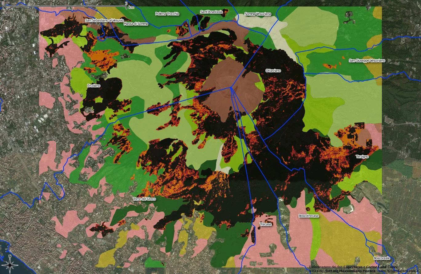
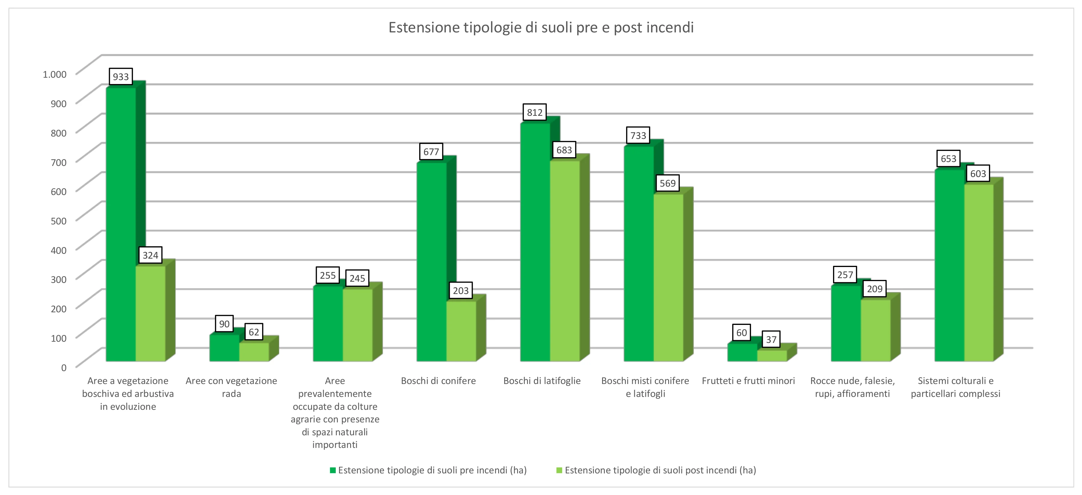
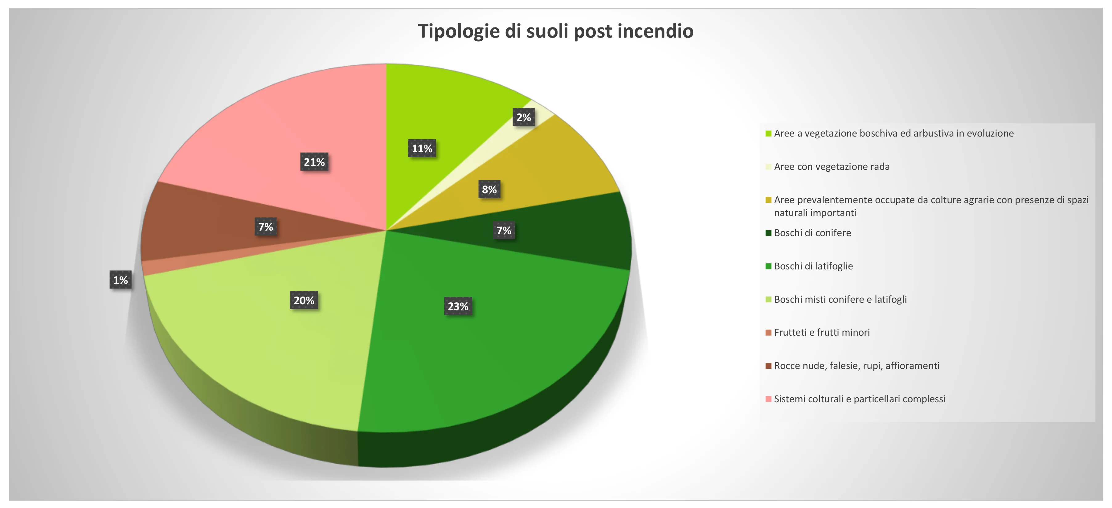
The largest extensions concern the wooded areas and unfortunately they are the ones that have had the greatest damage. The following image represents the post-fire scenario.
| CLC2000 soil description | Extension type of soil pre fires(ha) |
Areas completely destroyed (ha) |
Highly areas damaged (ha) |
Weakly areas damaged (ha) |
Extension type of soil post fires(ha) |
|
|---|---|---|---|---|---|---|
| Areas with evolving woodland and shrub vegetation | 932.96 | 447.29 | 114.31 | 47,46 | 323.90 | |
| Areas with sparse vegetation | 89.8 | 15.88 | 7.72 | 3.93 | 62.7 | |
| Areas mainly occupied by agricultural crops with the presence of important natural spaces | 255.31 | 7.78 | 1.81 | 0.65 | 245.07 | |
| Coniferous forests | 677.04 | 334.90 | 88.02 | 50,68 | 203.44 | |
| Broadleaf forests | 811.5 | 50.09 | 30.25 | 47.90 | 683.26 | |
| Mixed coniferous and deciduous forests | 732.78 | 108.42 | 35.94 | 18.89 | 569.44 | |
| Orchards and minor fruits | 59.6 | 9.40 | 5.37 | 8,11 | 36.72 | |
| Bare rocks, cliffs, cliffs, outcrops | 257,17 | 38.62 | 7.96 | 1.49 | 209.10 | |
| Complex cultivation and particle systems | 653,18 | 32.79 | 11.84 | 5.63 | 602.92 | |
| Total extent | 4,469.34 | 1,045.17 | 303.22 | 184.83 | 2,936.12 |
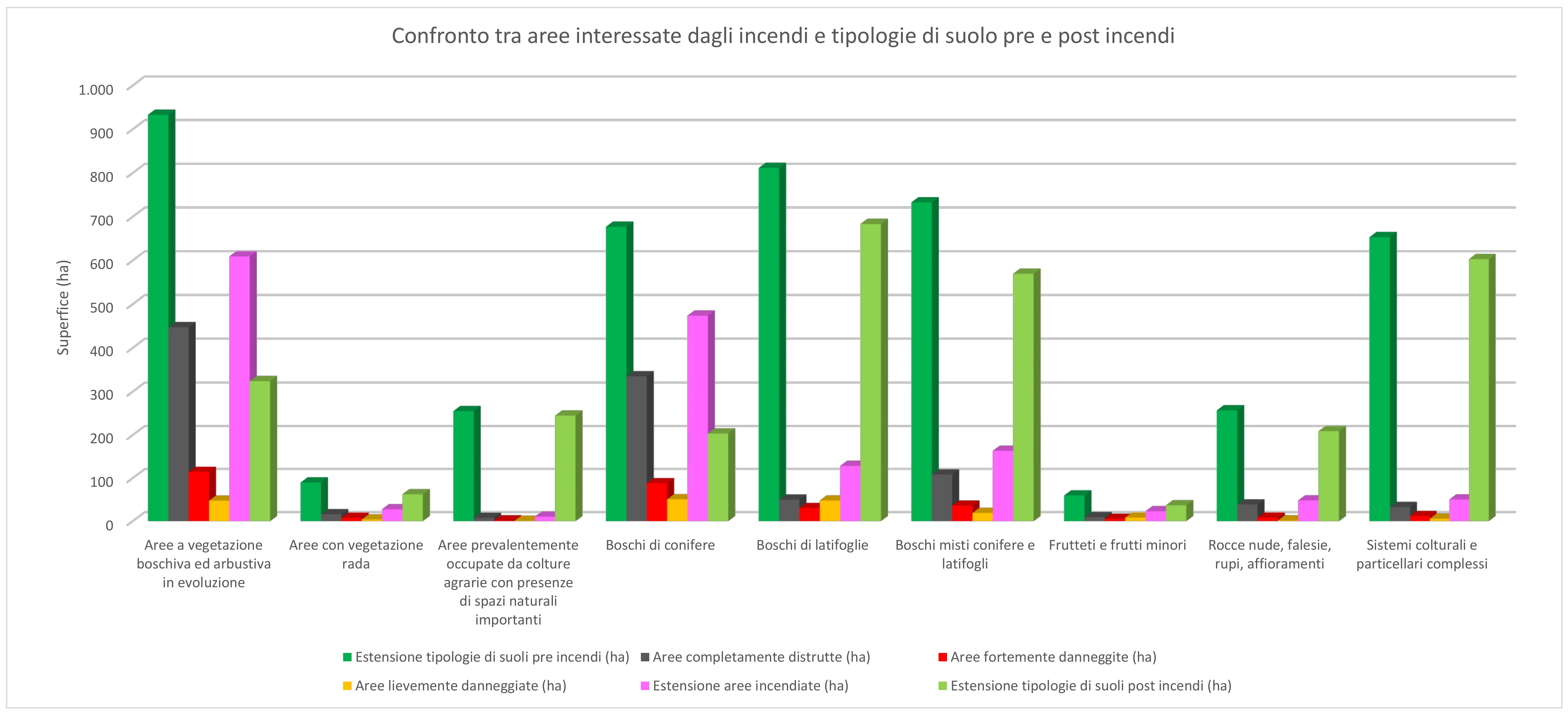
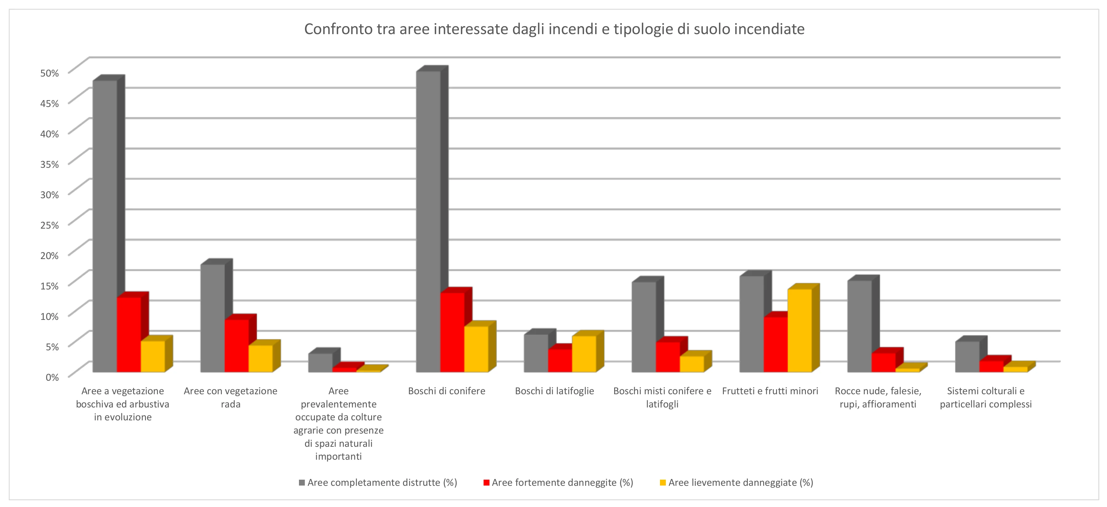
Analyzing the data in the previous table is It's easy to assess which is gone up in smoke:
- 70% of the coniferous forests, going from 677.04 ha to 203.44 ha;
- 65% of the evolving woodland and shrubby vegetation areas, going from 932.96 ha to 323.90 ha;
- 38% of the areas with orchards and minor fruit, going from 59.6 ha to 36.72 ha.
This is just to mention the first three types of soles for damage suffered. The totally destroyed areas, falling within the Vesuvius National Park, cover an area of 1,045.17 ha; For comparison, a regulation 11-a-side football pitch is about 1 ha.
Below are some comparison diagrams.
What should we expect with the next rains, typically heavy especially between September and October? We'll see, unfortunately.
In the meantime, I am heartened by the fact that nature is slowly regaining its spaces; to restore the woods however it will take years if not centuries!
Below is can download:
- the vector with the final extrapolation of the data;
- a PDF summarizing the data shown here.
Software used for processing:
We thank the following organizations:
![]()

![]()